|
|
Pakistan Monsoon 2024 Analysis Pakistan Meteorological Department-CDPC (18th October 2024) (Contact: info.cdpc@pmd.gov.pk, pmdcdpc@yahoo.com)
|
|
||
|
Monsoon 2024
(1 July - 30 September) Report 1. Pakistan Monsoon (July-September) highlights in 2024 |
||||
|
• The Cyclonic Storm “Asna” was a rare cyclonic storm originated in the Arabian Sea in the month of August 2024. • Monsoon rainfall during 2024 was excessively above average (+51%) with national total rainfall of 212.1mm. • Monsoon rainfall was above average over Balochistan (+111 %), Sindh (+108%), Punjab (+48), about average over Gilgit Baltistan (GB) (2%) and Khyber Pakhtunkhwa (KP) (-5%). While below average over AJK (-21%). |
Fig-1: Significant
climate events during monsoon-2024 |
|||
|
• The Monsoon rainfall in 2024 over Balochistan & Sindh was significantly high and it ranked as the 4th and 10th wettest monsoon respectively since 1961. • Monsoon season 2024 national mean temperature of 30.59 °C, for Pakistan, as a whole, was 0.71 °C warmer than average and ranked 4th highest mean temperature in past 64 years (the record is 30.63 °C in 2019). • The heaviest one-day rainfall of 337.0 mm occurred at Lahore Airport (Punjab) on 1st August. The same station observed the wettest month with a total of 603.0 mm in August-2024 and the wettest season with a total of 951.1 mm rainfall. • The hottest day of the season was observed at Dalbandin & Nokkundi on 4th July 2024 and Turbat on 7th July 2024 (all from Balochistan) when they recorded a maximum temperature of 49.0 °C. Whereas the stations Dalbandin & Nokkundi recorded the warmest month temperature with highest mean monthly maximum temperature of 45.1 °C. • The coldest night temperature (7.3 °C) of the season was recorded at Skardu (GB) on 30th September 2024. Coincidently, the same station recorded the coolest month’s temperature with lowest mean monthly minimum temperature of 11.1 °C in September 2024. (Fig-1) 2. Introduction Monsoon is a natural source of fresh water to fill wells, aquifers and keep rivers and streams flowing which are crucial for irrigation, domestic use and hydroelectric power generation. Timely and sufficient monsoon rains are critically important for agriculture, livestock, sustaining rivers and stream flows to feed water reservoirs and ground water recharge. Good monsoon rains not only boost up the Kharif crops but also keep the soil sufficiently moist which proves useful for ensuing Rabi crops in the country and hence the net agriculture productivity and exports get a boom which helps economic growth increase. However, the excess rainfall, like the one Pakistan experienced during monsoon 2022, causes massive devastation. On the other hand, deficient monsoon rains trigger drought like situations resulting food insecurity, dry vegetation, lower down water levels in lakes and reservoirs, land subsidence, seawater intrusion, and damage to ecosystems. 3. Monsoon 2024 This
year, the monsoon season set on in Pakistan on June 29, 2024, two days earlier
than its usual start date of July 1st. July and September 2024
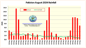
experienced a slightly deficient rain, but it was the August 2024 which
brought excessively above-average rainfall that compensating for deficient
July and September made the seasonal aggregate rains well above-average. To sum
it up, Pakistan experienced excessively above-average rainfall during the
entire monsoon season with a +51% deviation from the normal and ranked 8th
wettest monsoon rainfall during the past 64 years (record is 387.8mm in 2022).
On a regional scale, Balochistan and Sindh had excessively above-average
rainfall (+111% & 108% respectively), while Punjab had also well above‑average
rainfall (+48%). The Khyber Pakhtunkhwa (KP) and Gilgit Baltistan (GB) (with
-5% & +2% respectively) received near-average rainfall, whereas, Azad Jammu and Kashmir (AJ&K) (with ‑21%)
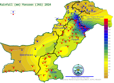
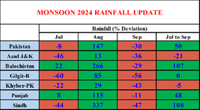
was the only region to receive below-average rainfall (Fig. 2a & Table-1). Fig. 2b shows the spatial distribution seasonal (JAS) rainfall
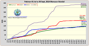
and Fig-3 gives the comparison of
cumulative monsoon rains this year and the previous two years. 4. The Climate drivers and
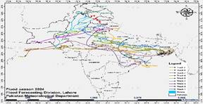
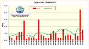
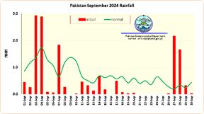
Synoptic Features during the Monsoon 2024: · The Sea Surface Temperature (SST) in the Central and Eastern Pacific started decreasing since Apr/May 2024 and turned to a neutral phase. However, in August, the El Niño–Southern Oscillation (ENSO) slightly shifted from neutral to La Niña with sea surface temperatures (SSTs) being around -0.4 °C over the central equatorial Pacific Ocean. Neutral to week La Niña conditions coupled with Maddan-Julian Oscillation (MJO) being in phases 2 & 3 over the Indian Ocean during August 2024 led to excessively above-average rainfall across Pakistan. · Indian Ocean Dipole (IOD) remained in neutral phase. · The monsoon axis, a line extending from the center of the seasonal low to the Bay of Bengal in the east, remained close to its normal position during July, mostly south of its normal position in August, and during September it shifted closer to the Himalayan foothills, diminishing the inflow of monsoon currents to Pakistan which however revived to its normal position during last days of September. · Two low-pressure areas (LPAs) moved in over Pakistan during July with heat-low (average pressure 991 HPa) persisted over Northwest Balochistan. During August, four LPAs moved over the country with heat-low (average pressure 994 HPa) persisting over North-northwest Balochistan. Whereas three LPAs approached in September with a heat low (average pressure value 1000 HPa). The tracks of LPAs are depicted in Fig-4. These factors played a significant role in final shape up of the Monsoon 2024. July 2024: · Monsoon currents converged over the country at regular intervals (1-2, 4-7, 13-15, 18-20, 23‑26 and 28-30 of July) during the month pouring light to moderate rainfall spell (Fig-5). · National rainfall was slightly below average (-8%) across Pakistan. · Regions also experienced below-average rainfall including GB (-60%), AJ&K (-46%), Sindh (‑44%), KP (-22%). In contrast, Balochistan (+22%) and Punjab (+8%) were the two regions with positive rainfall anomaly (Table-1). August 2024: · August saw the four monsoon LPAs (1-9, 11-13, 16-23 and 25-31 of August) resulting in moderate to heavy/very heavy rainy spells (Fig. 6). · In contrast to July, an excessively above-average rainfall was experienced in August with National rainfall being 147% above average. · Sindh (+337%), Balochistan (+266%), Punjab (+115%), GB (+85%), KP (+29%) and AJK (+13%) all recorded above to excessively above-average rainfall (Table-1). · Record breaking rainfall (wettest August) were recorded at Khuzdar 237.7mm, Lahore Airport 603.1mm, Mirpukhas 384.9mm Multan Airport 275.6mm and Rahin Yar Khan 258.2mm. Whereas new record for heaviest one-day rainfall was set at Lahore Airport with 337.0mm on 1st August, Rahim Yar Khan with 92.2 mm on 4th August and Sukkur with 100.0mm on 18th August 2024. September 2024: · September also saw four rainy spells (1-4, 7-8, 11-15, 17 and 27-29 Sep) but of light to moderate intensity which rendered it below average by -30% (Fig. 7). · All the regions GB (-56%), Sindh (-47%), KP (-43%), AJ&K (-36%), Balochistan (-29%) and Punjab (-11%) exhibited below average rainfall (Table-1) These variations in rainfall are indicative of the dynamic nature of the monsoon season in Pakistan. 5. Minimum and Maximum
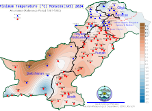
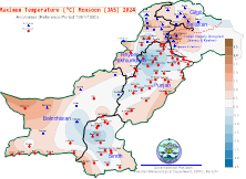
Temperature Trends during Monsoon-2024: The mean minimum temperature anomalies (-3.7°C to +5.2°C) for the monsoon 2024 season were considerably higher across most parts of the country (with maximum over the northwest Balochistan) except isolated places in southeast-southwest Balochistan, extreme north KP and GB where it was below-average (Fig. 8). The mean maximum temperature anomalies were in the range of ‑1.9°C to +3.2°C and found higher over AJ&K & western Balochistan (Nokkundi & adjoining areas) (Fig. 9). |
||||
|
Fig. 2(a).
Rainfall departure during monsoon 2024 |
Fig. 2(b). Monsoon-2024 rains’ spatial distribution |
|||
|
Fig. 3. Comparative cumulative rainfall (2022, 2023
& 2024) |
Fig.4. Monsoon
LPAs tracks during Jul-Sep 2024 |
|||
|
Fig. 5. July 2024 daily rainfall |
Fig. 6.
August 2024 daily rainfall |
|||
|
Fig. 7. September 2024 daily rainfall |
Table 1. Monthly &
seasonal rains departures |
|||
|
Fig. 8. Minimum Temperature Anomaly Monsoon 2024 |
Fig. 9. Max temperature
Anomaly Monsoon 2024 |
|||
|
5. Cyclonic Storm,
CS (ASNA, اسنیٰ) The formation of a Cyclonic Storm (CS, ASNA)
in a peak monsoon month of August was a rare
phenomenon. Normally, cyclones do not form during the monsoon primarily
because of strong vertical wind shear (VWS). Before this there were only
three instances when the CS formed in August, i.e. 1944, 1964 and 1976 during
the entire data period of 1893-2023. The CS, ASNA (31 Aug- 2 Sep)
dates back when a monsoon low formed on 16 Aug at Bay of Bengal (BoB),
gradually intensified first into well‑marked
low |
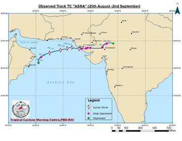
Fig-10: Track of CS
Asna |
|||
|
over Utter Pradesh (India) then into a depression over Madhya Pradesh (India) on 25 Aug. It further intensified into Deep Depression (DD) over East Rajasthan (India) on 26 Aug. Moving westward it remerged into the Northeast Arabian Sea and further intensified into Cyclonic Storm, ASNA (اسنیٰ) on 30th August. After tracking west-southwest for the next two days it gradually weakened first into Deep Depression on 1st Sep then into a depression on 2nd September (Fig-10). Nevertheless, the CS triggered squally winds of 40‑46 knots in Karachi division, Sujawal, Thatta and parts of Badin districts associated with widespread rain/thunderstorm with some extremely heavy falls over southern Sindh which uprooted dozens of trees, smashed signboards and blown away loose structures. Apart from this, its induced circulation also produced heavy rains in Balochistan, Khyber Pakhtunkhwa (KP), Punjab, Gilgit Baltistan (GB) and Azad Jammu & Kashmir (AJK) during 25-31 August. |
||||
|
6. Damages reported during the
Monsoon-2024 According to the National Disaster Management Authority1, about 357 people have been died, 668 people have been injured, about 501km of roads, 42 bridges, 58191 houses and 2282 livestock have been affected/damaged during Monsoon from 1st July to 13th September 2024. Issued by Director, Climate Data Processing Centre, Pakistan Meteorological Department Meteorological Complex, Gulistan e Jauhar, Block #5, Karachi-75290 Webpage: https://cdpc.pmd.gov.pk/; Email: info.cdpc@pmd.gov.pk Tel: 021-99261412-13 Technical
Note No. CDP/1-2024, Published on October 18, 2024 Reference 1.
NDMA, Monsoon Daily Situation Report. No. 75, vide
Director Response No. F.2 (E)/2024-NDMA (MW/SITREP-75) dated 13 September
2024 https://www.ndma.gov.pk/storage/sitreps/October2024/gXzrhIenhaI38kbEdUFi.pdf |
||||


